

Pinecrest Trails is a collaboration of many contributors who have submitted trail maps, descriptions and stories of hiking and biking trails near Pinecrest , California.
For over 100 years, hikers, bikers and equestrians have explored the Pinecrest basin by foot, bike and in the past horse. We hope you enjoy the collection of trails and please consider submitting your own trail maps, descriptions, and stories if you wish to have it posted on this site. On this site you will find a wealth of trail resources that vary from looking at historical topos dating back to 1907 and many new maps that list some of the hiking and biking trails of today.
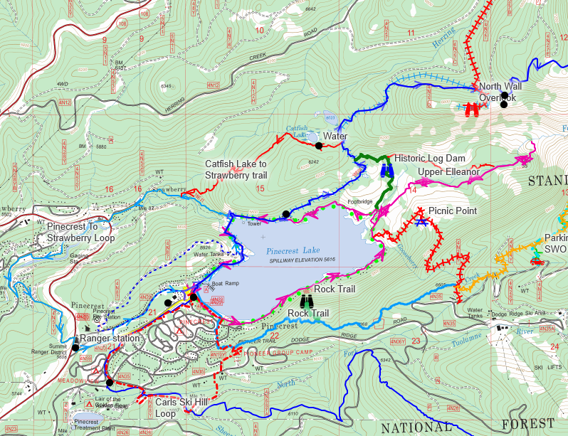
One of the best ways to use the resources of the Pinecrest Trails Website is to download the latest trail PDF map to your phone into the Avenza app or other GPS enabled PDF map viewers. This map will work off line without Internet and allows use to use the built in GPS functions with the trail map.
You can also run a full screen computer version of the map too to explore larger hiking regions and have options to view other very sophicated map layers.
Getting the current map downloaded or viewed on the Internet Options:
We have created two ways to view the topo map that shows the local Pinecrest trails
Method 1 works better on a full size computer screen. Method 2 works better on a phone or tablet.
Method 1: Requires active Internet on your device or computer
For an on-line interactive GPS maps of some of the trails listed here using the CALTOPO app, click our recent Pinecrest Trails Map on your computer or mobile device by clicking on the map below.
CLICK HERE or on map below which will send you to:
Method 2: Viewing them on a mobile device off line without Internet while hiking
UPDATE – July 2026 – Avenza Maps NO LONGER support any free map options so we have moved to a new phone PDF map reader.
GPS Trail Map for Your Phone
Navigate the Pinecrest Trails—Even Without Cell Service
The Pinecrest Trails Map is a GeoPDF, allowing your phone’s built-in GPS to display your location directly on the trail map—even when there is no cell service.
Step 1 – Install GeoPDF Viewer
Currently we can not identify a single free app that will allow you to download and view a geo PDF off line
App for a fee include:
CalTopo.com – $20 per year
https://store.avenza.com/pages/pricing – $35 per year
Step 2 – Download the Pinecrest Trails Map
Cal Topo use https://caltopo.com/m/8N2L
Avenza – User PDF map -Click the link below to download the map to your phone:
https://pinecresttrails.org/wp-content/uploads/2026/05/mapside202612x18.pdf
Step 3 – Open the Map and save it for off-line use
Step 4 – Turn On GPS
The first time you open the app, allow it to access your location.
Tap the Location (crosshair) button to display your current position on the map.
Before You Hike
- Download the app while you have an internet connection.
- Download the Pinecrest Trails map before heading to the trail.
- Open the map once to make sure it has loaded correctly.
- Turn on your phone’s Location Services.
Once the map has been downloaded, no internet or cell service is required. Your phone’s GPS will continue to show your location anywhere on the map.
Download the Pinecrest Trails Map or Access CalTop map and download it.
https://pinecresttrails.org/wp-content/uploads/2026/05/mapside202612x18.pdf
Need More Information?
Visit https://pinecresttrails.org for additional trail maps, trail descriptions, current conditions, and volunteer opportunities.
Happy hiking!
The Current 2026 PDF map is available as (click below to load PDF)
Pinecrest Trails Map 2025 Last year’s map
Here is the URL to the PDF map:
Click to access mapside202612x18.pdf
(Optional map showing Cooper Peak area Geospacial PDF) – Bigger scale and areas East of Pinecrest.
URL is
Method 3: Print a map
The PDF map is also printable 12×18 inch PDF document that can be printed at local copy and print shops. The PDF downloaded in method 2 can be printed on 12×18 paper stock.


I had the honor of being one of the first to take the rock wall connection route today. A fine bit of Pinecrest history.
Thanks!
LikeLike
Tried the Bear Trail yesterday.
7/12/23
1/2 way down, on the face overlooking the lake, the trail vanished or was completely overgrown. I spent 45 min lookin in all directions. The brush was very thick in all direction and I was getting cut up a bit. I finally had to withdraw due to the impending sunset. Not fun hiking all the way back up the mountain being chased by mosquitoes. Yikes. Gonna see if I can find the bottom of the trail by the lake today.
Perhaps someone that knows this trail could try it soon to confirm.
The trail vanishes around the 6200’ marking on the map.
LikeLike
The trail is there. – please download the geo spacial PDF to help find it easier. If I knew where you got lost we can mark the trail better.
LikeLike