
Pinecrest is a very special location since the dividing line between two watersheds cut right through Pinecrest!
Typically when you walk to Pinecrest lake you are crossing of the watershed boundary once or twice and you have no idea you have cross into a new watershed.
There are even a few cabins and a few campground sites on D LOOP where you can literally spit into the Tuolumne Watershed and turn around the throw water into the Stanislaus Watershed.
- To the more northern/eastern side of Pinecrest, all of the water will run into the lake or into the Stanislaus Water shed, into the south fork of the Stanislaus.
- To the southern side, the water will run into a completely different water shed and into the Tuolumne watershed, into the North Fork of the Tuolumne River.
The graphic below shows a first attempt to map the boundary between Stanislaus Watershed (to the East, (right) of the blue line) and the Tuolumne Watershed (to the left or West of the blue line).
You can click view this map on line with your phone or other device and determine where you are by clicking on the on-line map at:
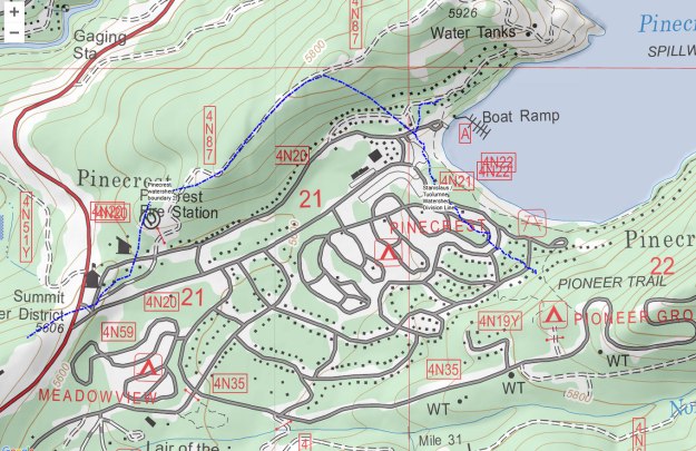
All of the drainage that starts near the lake drains out toward the ranger station and past the Cal camps, and flows meets into the north fork of the Tuolumne on the Crab Tree Road.
A second small section of Pinecrest near the ranger stand also has boundary areas where Stanislaus watershed is on the northern side of their access road and the Tuolumne watershed is to the south.
It is difficult to determine exactly where the drainage boundary exists above the cabins on Granite lane whether they drain into Pinecrest Lake or drain in the meadow behind the store. That line shown is an approximation of the watershed boundary.
